We're starting into a (somewhat brief) pattern of warmer and brighter weather, for the next couple of days. A few areas, mainly the coast and north, are seeing some light rainfall this morning and will see showers taper this afternoon thanks to a weak system brushing the coastline, but overall the clouds are thinning the further south and east you go. Sun fans, enjoy the next two days, because the weekend is looking a little bit damp at times. Not a soaker, but definitely not completely dry. In the meantime, today the sun will break through at times and temperatures will press into the mid 60's in most places. Overnight, we will be in the upper 40's to low 50's for the majority, under partly cloudy skies in the interior and mostly cloudy skies near the coast, where some scattered to isolated showers might still remain.
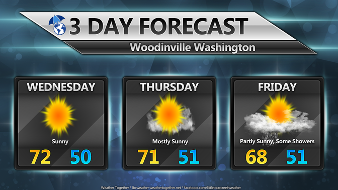
Our midweek Wednesday is all-in for the sun fans, as we push the mercury up towards the low to mid 70's for most under mostly sunny to sunny skies. There might be some brief clouds near the waterways and out on the coast again, but they should burn off quickly as we will have brief upper level ridging in place to keep the rain off to the east and the west for the short term to keep us dry and sunny. Get out and enjoy the blue skies if you can, it should be a wonderful day around the Sound! Wednesday night could perhaps usher in some minor marine breezes and onshore flow late in the evening, bringing the temperatures down and along for the ride some clouds. Overnight we will be in the low 50's for most, under mostly cloudy skies late. Thursday will start with a morning marine layer, but is likely to burn off later in the afternoon to mostly sunny conditions, but a tad cooler than Wednesday, with highs touching the upper 60's to possibly low 70's in the warm spots. Thursday night will be our brief transition period, temperatures will be in the upper 40's to low 50s' again.
Friday, change arrives, and the coin begins to flip toward favoring the rain fans. Light rain will arrive at some point on Friday, models are still arguing over the exact timing of it's arrival, likely late morning or early afternoon. The weekend also looks wet at times, rain likely both days, with temperatures running cool and a bit below normal in the low to mid 60's. We're not talking full blown washout status in most areas here but a few tenths of an inch of rain is possible, and perhaps a half inch or so, potentially more ONLY if you happen to get caught in the Puget Sound Convergence Zone, should it develop. There is a good chance both days that it could do so, bringing a combined weekend rain total to a half inch or more in those spots.
Looking further out into next week, models are struggling with potential moisture, where it will end up and potential arrival times, but it is still early with plenty of time for change. Temperatures appear to remain near normal during that time period, as of right now, in the upper 60's, near 70. If you are a rain fan, you have plenty of chances for some pluviophile goodness coming up, and sun fans, enjoy the warm and sun the next few days, you might have to seek out those sun breaks by late week!